Gemeinde Brunow
What is it? Where is it?

Contents

What is Gemeinde Brunow?

Where is Gemeinde Brunow?

Geography


Village Pictures

--Brunow Village Pictures
--Bauerkuhl Pictures
--Klüß Pictures

Other Links

Geographic and Political History of Mecklenburg

History of Gemeinde Brunow

History of the Villages of Gemeinde Brunow, Karl-Heinz Steinbruch

Geschichte der Dörfer Gemeinde Brunow, Karl-Heinz Steinbruch

The Church at Brunow

Inside the Church at Brunow

Gemeinde Brunow - Gold Medal Winner

Gemeinde Brunow Today

Erntefest

Brunow Fire Department

Youth Circus Weekend

Brunower Bauernmarkt

Picture Gallery


Official Amt Grabow Online Portal - German Language only


Related Links

Picture of Brunow Church Tower January 2003

Introduction

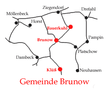
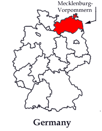
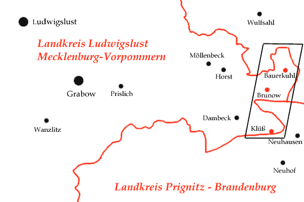
The village of Brunow (which is a part of "Gemeinde Brunow" in north-east Germany) is the village where my ancestors lived and attended church for the last 70 years before they left for America.

On this page and the associated pages I have attempted to tell the story of "Gemeinde Brunow", a rural community in modern-day Germany.  I think you find it very interesting.

What is Gemeinde Brunow?

Gemeinde Brunow is a district made up three neighboring rural villages: Brunow, Klüß and Bauerkuhl.

Map showing the villages of Gemeinde-Brunow Clear image

Where is Gemeinde Brunow?

Gemeinde Brunow is located in the German state of Mecklenburg-Vorpommern which is the northeastern-most state in Germany (See the map to the right).


Gemeinde Brunow is located in Landkreis (county) Ludwigslust which is in the south-west corner of Mecklenburg-Vorpommern. (See the map at the lower left).


Landkreis Ludwigslust is divided into nineteen Amts (administrative districts). Gemeinde Brunow is one of 15 communities in Amt Grabow-Land. Amt Grabow-Land is in the south-east corner of Landkreis Ludwigslust. (See the map at the lower right)

Outline Map of German States
Outline Map of Landkreis Ludwigslust Outline Map of Amts in Landkreis Ludwigslust

Geography

Gemeinde Brunow is near the border between the states of Mecklenburg-Vorpommern and Brandenburg.   The village of Brunow is in the middle of Gemeinde Brunow with Bauerkuhl lying 2.9 km (1.8 miles) to the northeast and Klüß 3.9 km (2.4 miles) to the south-southeast.  (See map below)


Map showing border
Another Brunow area map

The largest cities in the area are Grabow, Ludwigslust, Parchim and Perleberg. Below is a table showing the populations and distances to those cities and the major capital cities.

Distances from Major Cities to Village Brunow
City Population Distance(km) Distance(miles) Direction
Grabow 6,700 16 10 West
Ludwigslust 12,500 21 13 West-North-West
Perleberg 13,900 23 14 South-South-East
Parchim 20,050 19 12 North
Schwerin (capital of Mecklenburg-Vorpommern) 101,270 49 31 North-West
Berlin (capital of Germany) 3,382,170 136 85 South-East
Clear image
right arrowClear imageGeographic and Political History of Mecklenburg

Clear image Top of page Gemeinde-Brunow Home Page The Thies Family of Brunow and Horst Home Page David Thies Home Page

This page was last updated on 4 May 2003

This page created by David Thies - Contact me via e-mail

Valid HTML 4.0!

Visit Counter